Whether it’s wildfires that sweep across the West Coast, storms rolling in from the Pacific Ocean, or dense fog that blankets the Pacific Northwest, a new weather satellite will be able to track them all.The National Oceanic and Atmospheric Administration will launch GOES-T, the third in its series of advanced geostationary weather satellites, on March 1 from Cape Canaveral, Florida. Once the satellite is in orbit, it will be renamed GOES-18 and monitor weather that impacts the western United States, Alaska, Hawaii, Mexico, Central America and the Pacific Ocean.The satellite will provide our most sophisticated and sharpest look yet at what Earth’s Western Hemisphere looks like from 22,236 miles (35,785 kilometers) above the planet.GOES-T is equipped with a suite of instruments that can provide measurements of the atmosphere, map lightning in real-time and send back stunning ultra high-definition images. Its continuous collection of data will improve weather forecasting on Earth.Together with the GOES-16 satellite, which launched in 2016, the two will actively monitor more than half the globe, spanning from the west coast of Africa to New Zealand.”The observations from these satellites are even more critical now, when the U.S. is experiencing a record number of billion-dollar disasters,” said Pam Sullivan, director of NOAA’s GOES-R program, during a press conference. “Compared to the previous generation, GOES-R satellites deliver 60 times more imagery, and they have a new lightning camera to track severe storms that spawn tornadoes and damaging winds.”The northeastern part of the Pacific Ocean is where many of the storms that impact the U.S. begin.”Since many of the weather systems of the United States move from west to east, GOES-T will improve model forecasts for the entire country,” said James Yoe, chief administrative officer for the Joint Center for Satellite Data Assimilation, during a press conference on Tuesday.And it’s not just reporting back weather on Earth — GOES-18 will also keep an eye on solar storms and space weather, providing early warnings ahead of any possible disruptions to our power grid on Earth.Tracking dangerous conditionsFlooding and mudslides in coastal areas can often be traced to a type of weather phenomena called atmospheric rivers. These “rivers in the sky” deliver columns of water vapor from the tropics and release rain or snow when they make landfall, according to NOAA. Hurricanes that form in the Pacific can spin toward Hawaii or Mexico.The GOES-T satellite will provide better monitoring of both types of weather events.Warm ocean surface temperatures can contribute to the formation of hurricanes, so the satellite’s monitoring of these increases could provide early warning about hurricane formation.The satellite’s capabilities will also help weather forecasters track and monitor tropical storms and hurricanes practically in real time, sharing data about the storm’s structure and features, wind speeds, and lightning. All of these factors can be used to calculate the intensity of a storm.Tracking rising ocean temperatures can also allow for better monitoring of marine heat waves that cause coral bleaching events en masse and alter entire marine ecosystems.Wildfires are another hazard for those living in much of the western U.S., and GOES-18 is armed with a multitude of ways to spot and peer inside the destructive nature of these extreme events.The satellite will be able to find wildfire hotspots, detect changes in the behavior of the fire, and predict its motion, as well as estimate the intensity, smoke output and air quality. It will also have the accuracy to identify the lightning strikes most likely to cause these fires and detect the pyrocumulonimbus clouds that form over wildfires.These massive clouds can stretch for miles. A dangerous combination of their size and heat allows the clouds to create their own weather and threaten firefighters trapped beneath them.”The Advanced Baseline Imager, or ABI, is ideal for detecting the thermal signature, or the hot spots, from the fires,” said Dan Lindsey, NOAA’s GOES-R program scientist, during the press conference. “Sometimes, it’s even able to detect the fires before they’re reported from the public. This is really critical information to get to firefighters so that they can take care of the fires before they can become out of control.”The satellite’s ABI can scan our planet five times faster with four times the resolution of previous geostationary satellites. And the instrument recently surprised NOAA scientists with another previously unknown capability: detecting pressure waves from volcanic eruptions, which they were able to do after the recent Tonga eruption.And the GOES satellites don’t just monitor Earth. They have specialized instruments that image the sun and spot solar flares and monitor incoming space radiation particles. Without proper tracking or early warnings, this space weather can damage satellites that provide the basis for our communications and GPS, as well as spacecraft like the International Space Station.Once GOES-18 is operational, it will replace the current GOES-17 satellite, which will remain in orbit as a spare. Post-launch testing of GOES-17 in 2018 revealed an issue with the cooling system on the satellite’s imager, leading to a loss of imagery from time to time. This issue was corrected in the ABI for GOES-18, which will effectively replace GOES-17’s monitoring of the western hemisphere.The agency anticipates that the first imagery and data from GOES-18 will be available in the summer of 2023.
Whether it’s wildfires that sweep across the West Coast, storms rolling in from the Pacific Ocean, or dense fog that blankets the Pacific Northwest, a new weather satellite will be able to track them all.
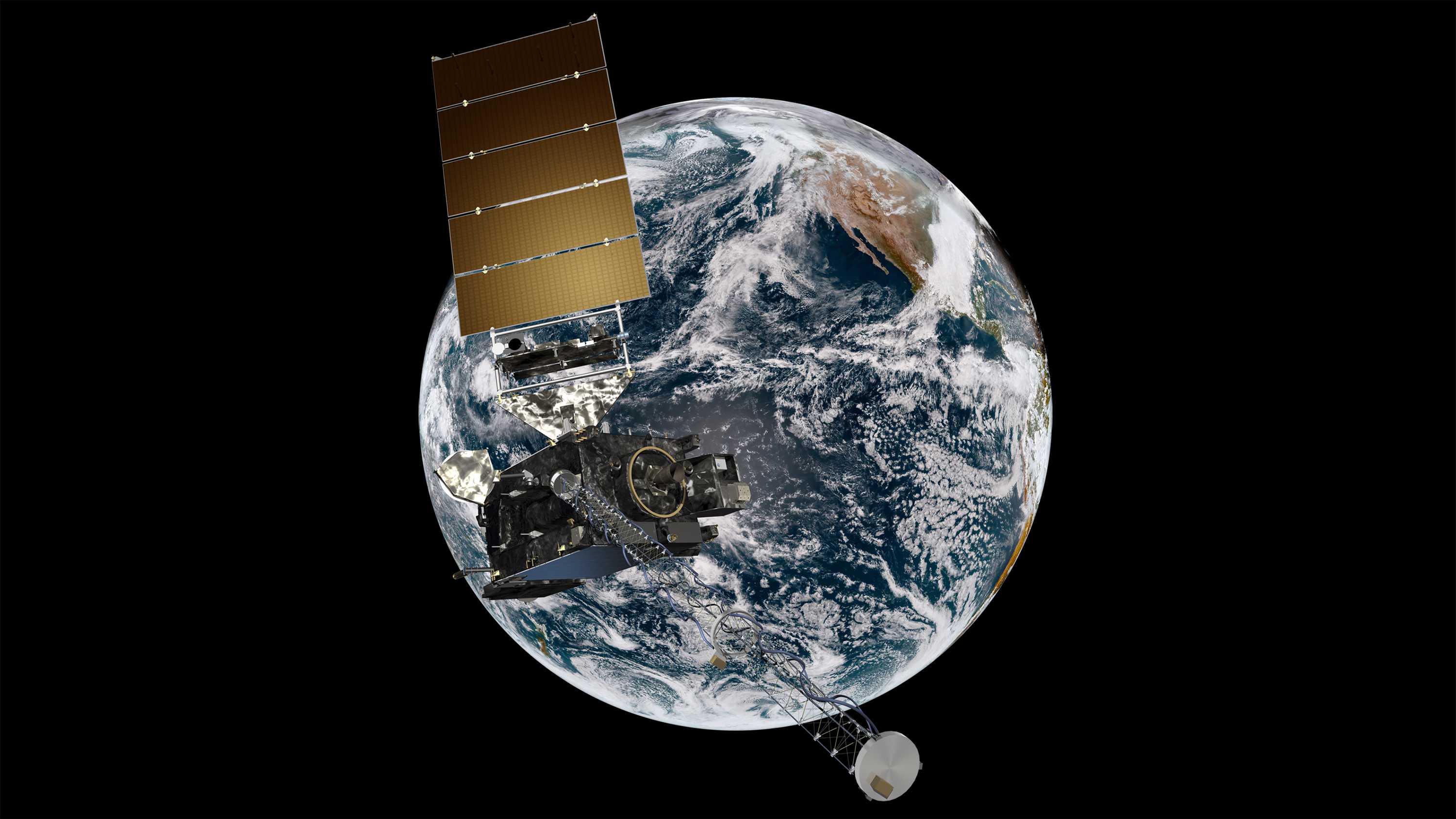
The National Oceanic and Atmospheric Administration will launch GOES-T, the third in its series of advanced geostationary weather satellites, on March 1 from Cape Canaveral, Florida. Once the satellite is in orbit, it will be renamed GOES-18 and monitor weather that impacts the western United States, Alaska, Hawaii, Mexico, Central America and the Pacific Ocean.
The satellite will provide our most sophisticated and sharpest look yet at what Earth’s Western Hemisphere looks like from 22,236 miles (35,785 kilometers) above the planet.
GOES-T is equipped with a suite of instruments that can provide measurements of the atmosphere, map lightning in real-time and send back stunning ultra high-definition images. Its continuous collection of data will improve weather forecasting on Earth.
Together with the GOES-16 satellite, which launched in 2016, the two will actively monitor more than half the globe, spanning from the west coast of Africa to New Zealand.
“The observations from these satellites are even more critical now, when the U.S. is experiencing a record number of billion-dollar disasters,” said Pam Sullivan, director of NOAA’s GOES-R program, during a press conference. “Compared to the previous generation, GOES-R satellites deliver 60 times more imagery, and they have a new lightning camera to track severe storms that spawn tornadoes and damaging winds.”
The northeastern part of the Pacific Ocean is where many of the storms that impact the U.S. begin.
“Since many of the weather systems of the United States move from west to east, GOES-T will improve model forecasts for the entire country,” said James Yoe, chief administrative officer for the Joint Center for Satellite Data Assimilation, during a press conference on Tuesday.
And it’s not just reporting back weather on Earth — GOES-18 will also keep an eye on solar storms and space weather, providing early warnings ahead of any possible disruptions to our power grid on Earth.
Tracking dangerous conditions
Flooding and mudslides in coastal areas can often be traced to a type of weather phenomena called atmospheric rivers. These “rivers in the sky” deliver columns of water vapor from the tropics and release rain or snow when they make landfall, according to NOAA. Hurricanes that form in the Pacific can spin toward Hawaii or Mexico.
The GOES-T satellite will provide better monitoring of both types of weather events.
Warm ocean surface temperatures can contribute to the formation of hurricanes, so the satellite’s monitoring of these increases could provide early warning about hurricane formation.
The satellite’s capabilities will also help weather forecasters track and monitor tropical storms and hurricanes practically in real time, sharing data about the storm’s structure and features, wind speeds, and lightning. All of these factors can be used to calculate the intensity of a storm.
Tracking rising ocean temperatures can also allow for better monitoring of marine heat waves that cause coral bleaching events en masse and alter entire marine ecosystems.
Wildfires are another hazard for those living in much of the western U.S., and GOES-18 is armed with a multitude of ways to spot and peer inside the destructive nature of these extreme events.
The satellite will be able to find wildfire hotspots, detect changes in the behavior of the fire, and predict its motion, as well as estimate the intensity, smoke output and air quality. It will also have the accuracy to identify the lightning strikes most likely to cause these fires and detect the pyrocumulonimbus clouds that form over wildfires.
These massive clouds can stretch for miles. A dangerous combination of their size and heat allows the clouds to create their own weather and threaten firefighters trapped beneath them.
“The Advanced Baseline Imager, or ABI, is ideal for detecting the thermal signature, or the hot spots, from the fires,” said Dan Lindsey, NOAA’s GOES-R program scientist, during the press conference. “Sometimes, it’s even able to detect the fires before they’re reported from the public. This is really critical information to get to firefighters so that they can take care of the fires before they can become out of control.”
The satellite’s ABI can scan our planet five times faster with four times the resolution of previous geostationary satellites. And the instrument recently surprised NOAA scientists with another previously unknown capability: detecting pressure waves from volcanic eruptions, which they were able to do after the recent Tonga eruption.
And the GOES satellites don’t just monitor Earth. They have specialized instruments that image the sun and spot solar flares and monitor incoming space radiation particles. Without proper tracking or early warnings, this space weather can damage satellites that provide the basis for our communications and GPS, as well as spacecraft like the International Space Station.
Once GOES-18 is operational, it will replace the current GOES-17 satellite, which will remain in orbit as a spare. Post-launch testing of GOES-17 in 2018 revealed an issue with the cooling system on the satellite’s imager, leading to a loss of imagery from time to time. This issue was corrected in the ABI for GOES-18, which will effectively replace GOES-17’s monitoring of the western hemisphere.
The agency anticipates that the first imagery and data from GOES-18 will be available in the summer of 2023.