This is Naked Capitalism fundraising week. 1270 donors have already invested in our efforts to combat corruption and predatory conduct, particularly in the financial realm. Please join us and participate via our donation page, which shows how to give via check, credit card, debit card, PayPal, Clover, or Wise. Read about why we’re doing this fundraiser, what we’ve accomplished in the last year, and our current goal, more original reporting.
Yves here. We’ve been regularly featuring tweets and links about some of the too-many large floods around the world. In many cases, they’ve been so severe and long-lived so as to damage agricultural output. This post provides an overview of the extent and severity of these floods and their drivers.
By Bob Henson and Jeff Masters. Originally published at Yale Climate Connections
Drawing on a record global supply of atmospheric moisture – and with a jet stream “stuck” in a mode identified in climate change research – a series of catastrophic floods has been slamming far-flung parts of the Northern Hemisphere in September.
- Flooding from persistent, unusually heavy rains across northwest and north-central Africa has taken more than 1,000 lives and driven close to 1 million from their homes.
- Storm Boris, a stalled upper low, has triggered days of intense rainfall, caused billions in damage, and forced tens of thousands to evacuate flooded cities across Central Europe.
- Typhoon Yagi, which struck the Philippines and northern Vietnam and then hauled moisture across the highlands of Southeast Asia, spawned floods and mudslides that have taken more than 500 lives and cost over $13 billion.
Lądek Zdrój, Poland….pic.twitter.com/6ob9owxwby
— Volcaholic 🌋 (@volcaholic1) September 15, 2024
One link among all of these systems: Warmer global temperatures allow more water to evaporate from oceans and intensify rainfall, even as they also suck moisture from parched landscapes where it’s not raining (the “wet get wetter, dry get drier” paradox). As measured via precipitable water – the amount of water vapor in an imaginary column over a given point – August 2024 was the wettest August on record globally and the 14th consecutive wettest month on record in analyses dating back to 1940.
Jet-stream weirdness is another factor in play in the Northern Hemisphere. The usual belt of tropical rainfall has been displaced much farther north than usual in Africa, which has moistened parts of the arid Sahara Desert and brought torrents of rain to the semiarid Sahel belt (and perhaps also helped suppress hurricanes across the Main Development Region of the Atlantic).
Lakes deep in the Sahara that rarely fill are doing so now after an extratropical cyclone pushed through parts of #Morocco and #Algeria. https://t.co/oyh1pFvNVY pic.twitter.com/1NJ9etFhKv
— Adam Voiland (@avoiland) September 14, 2024
Everything is stuck! That partly explains the 20” of rain along the Carolina Coast and extreme rains and snows in Central Europe. Take a look at the jet stream in the US and Europe. Rex blocks (high over top of low) abound with an extremely wavy jet stream! pic.twitter.com/R8B8PUoCRE
— Jeff Berardelli (@WeatherProf) September 16, 2024
At midlatitudes — the region of the globe that includes much of North America, Europe, and Asia — blocking patterns and cut-off upper lows have been prevalent in recent days, including Storm Boris and the slow-moving Potential Tropical Cyclone 8, which dumped more than 20 inches of rain on parts of the North Carolina coast. Research extending back more than a decade has pointed to a phenomenon called quasi-resonant amplification, or QRA, as an important factor in prolonged summer weather extremes across the Northern Hemisphere. Such events could become up to 50% more common this century as climate change unfolds, according to a key 2018 paper.
Michael Mann, a climate scientist at Pennsylvania State University and lead author of that paper, is now working to analyze how much the phenomenon may be involved in the recent Northern Hemisphere extremes. This work will take a few more days to finalize, Mann said in a direct message. He added: “What I can say is that this does look like a potential QRA pattern, consistent with our work suggesting that anthropogenic climate change is leading to an increase incidence of such setups.”
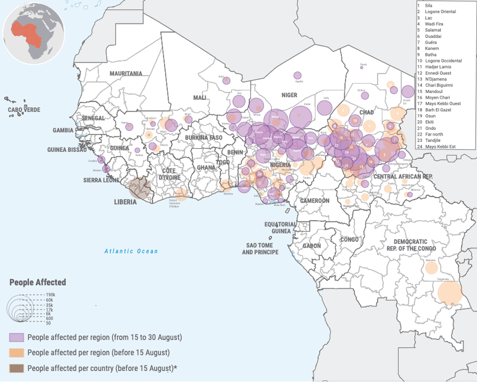
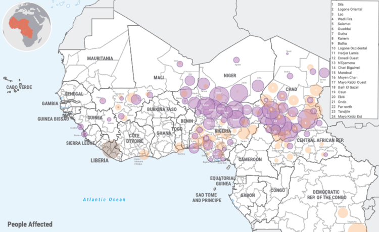
Flooding in West and Central Africa
Torrential rains during July, August, and September have unleashed catastrophic floods in West and Central Africa, affecting over 4 million people in 14 countries: Benin, Cameroon, Central African Republic, Chad, Côte d’Ivoire, Gambia, Guinea, Guinea Bissau, Liberia, Mali, Niger, Nigeria, Sierra Leone, and Togo. According to the U.N. World Food Program, the floods have exacerbated a regional hunger crisis that was already affecting 55 million people – four times more people than five years ago. At least 1,096 people have been killed in five of the countries, according to a variety of sources:
Chad: 487 killed, 70,000 homes destroyed, 1.6 million affected
Nigeria: 269 killed, 640,000 displaced
Niger: 265 killed, 69,000 homes destroyed, 649,000 affected
Mali: 55 killed, 344,000 affected, worst floods since the 1960s
Cameroon: 20 killed
The flood situation in Nigeria is off the scale. Just Horrific 😭pic.twitter.com/rGi3QcI0j8
— Volcaholic 🌋 (@volcaholic1) September 17, 2024
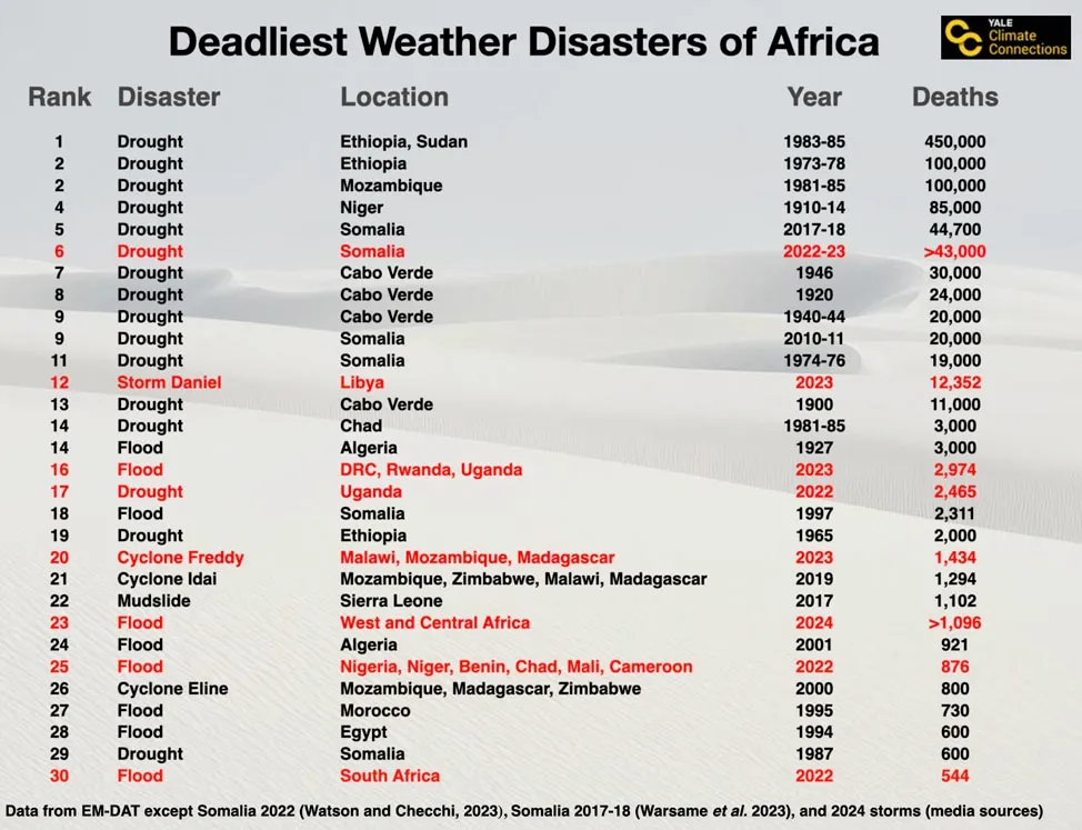
Climate Change Is Increasing the Severity of Deadly African Weather Disasters
Despite recent improved weather forecasting technology and increased disaster awareness and preparation efforts, the African continent has suffered an unprecedented number of deadly weather-related disasters over the past two years. This year’s floods are the eighth weather-related disaster to kill at least 500 Africans since 2022; an astonishing 27% of the continent’s 30 deadliest weather-related disasters since 1900 have occurred since 2022 (Fig. 2).
This ominous figure could well be a harbinger of the future, as higher vulnerability, a growing population, and more extreme weather events from climate change cause an increase in deadly disasters. For more detail, see our September 13, 2023, post on Storm Daniel, “The Libya floods: a climate and infrastructure catastrophe.”
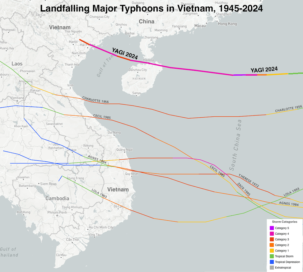
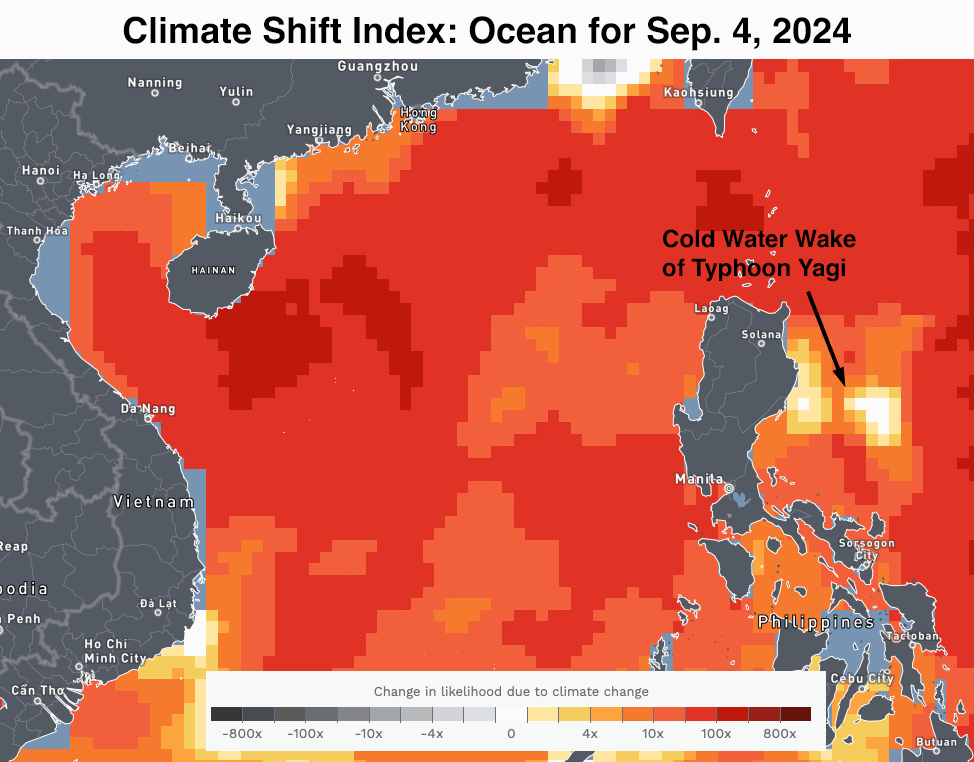
Typhoon Yagi
Typhoon Yagi made landfall on September 7 near Hai Phong, Vietnam, as a Category 4 storm with 130 mph winds and a central pressure of 933 mb, according to the Joint Typhoon Warning Center. Yagi was the first Category 4 or stronger typhoon to make landfall in Vietnam since modern records began in 1945. Prior to Yagi, Vietnam had been hit by only six Category 3 typhoons, the strongest of these being Typhoon Lola of 1993 (120 mph winds).
The economic and human toll of Yagi has been staggering. The typhoon killed 291 people in Vietnam, with 38 missing, as reported by Reuters. Most of the toll was from torrential rains in the northern portion of the country. At least 226 people have died in floods and landslides across Myanmar, according to AP, with 77 others missing and the economic toll still undetermined.
Vietnam has had three tropical cyclones that have killed over 1,000 people: Typhoon Iris of 1964 (7,000 deaths), Typhoon Linda of 1997 (3,683 deaths), and Tropical Storm 16W of 1953 (1,000 deaths).
According to the Vietnamese government, Yagi has cost Vietnam at least $2 billion, which would make it the nation’s costliest storm on record. According to EM-DAT, Vietnam has had five prior billion-dollar weather disasters (shown below along with Yagi in 2024 dollars):
- Drought, 2015, $8.7 billion
- Typhoon Yagi, 2024, $2.0 billion
- Typhoon Hato, 2017, $1.8 billion
- Typhoon Ramil, 2017, $1.2 billion
- Tropical Storm Ondoy, 2009, $1.1 billion
- Tropical Storm Linfa, 2020, $1.0 billion
Also hard-hit by Yagi was far southern China’s Hainan province, where four deaths have been reported and damage has exceeded $11 billion, according to regional authorities. According to EM-DAT, this would make Yagi the third-costliest Chinese typhoon on record (in 2023 dollars adjusted for inflation). The top six most expensive Chinese tropical cyclones:
- 1) $25 billion, Doksuri, 2023
- 2) $12 billion, Lekima, 2019
- 3) $11 billion, Yagi, 2024
- 4) $9 billion, Fitow, 2013
- 5) $6 billion, Rumbia, 2018
- 6) $4 billion, Rammasun, 2014
(This list leaves out what was possibly the most destructive Chinese typhoon of all time, Typhoon Nina of 1975. Nina stalled out and dumped prodigious rains for two days in the Ru River drainage basin upstream of the Banqiao Dam, leading to the dam’s collapse and the loss of 171,000 lives, with an area 34 miles long and eight miles wide wiped out. The disaster was not disclosed by China until the mid-1990s.)
Storm Boris in Europe
An unusually strong, cold upper low dove into southern Europe late last week, triggering the formation of a strong surface low over the Mediterranean Sea south of Genoa, Italy. This Genoa low evolved into Storm Boris and wrapped warm, moist air northward beneath the cold upper low across Central Europe while also forcing moisture southward and upslope against the Austrian Alps. Storm Boris drew some of its water vapor from a Mediterranean that hit its highest daily average surface temperature on record on August 15 (28.9 Celsius or 84°F).
The very slow movement of #Boris, the deep low which has brought extreme rainfall & caused devastating #floods in part of central Europe, can be clearly seen in this 5-day Meteosat Airmass loop, note the continuous northerly flow against the Alps, via Jochen Kerkmann pic.twitter.com/8IE9Z6aG82
— EUMETSAT Users (@eumetsat_users) September 17, 2024
The resulting temperature contrasts and strong instability led to intense showers and thunderstorms that dumped torrential rain and spawned widespread flooding across parts of Poland, Romania, Austria, the Czech Republic, Germany, and Slovakia. Tens of thousands of people have been evacuated and at least 21 killed. Some locations received five typical Septembers’ worth of rain in four days, as reported by The Guardian.
This graphic really highlights just how much rain has fallen in central Europe in the last few days.
Poland for example has doubled and in some spots tripled the record for September rainfall. Millions and millions of litres of water with no where to go. pic.twitter.com/iBnQ5eoW0Y
— Met4Cast. (@Met4CastUK) September 16, 2024
Although the rains from Boris had largely subsided by midweek, floodwaters were coursing down the Danube River toward Hungary and Slovenia and along the Oder River toward Wroclaw, Poland.
“These floods are a clear reminder of the growing threat of climate-induced extreme weather events,” Sissi Knispel de Acosta, the general secretary of the European Climate Research Alliance, told the New York Times. The World Weather Attribution group will release an analysis on Wednesday, September 25, on their research showing to what degree climate change may have affected the storm.
At higher elevations of the Austrian Alps, the cold upper low teamed up with moisture from Boris and upslope flow to produce an exceptionally early round of heavy snow. The snow piled up to 145 cm (4.76 feet) at Alpinzentrum Rudolsshutte (elevation 700 meters or 2,300 feet), a record-high total for Austria for any September event. Fraser Wilkin of weathertoski.co.uk told Planet Ski: “Although occasional (mostly) high-altitude snowfalls are nothing unusual in September, this degree of storm is not something we have seen this early for many years.”
Great thread on extreme weather forces fueling rampaging floods in Europe: “The bottom line here is that parts of Central Europe have never recorded a weather event like this. Not just in September, but for any month.” #climate https://t.co/GvC6IrrzG6
— Rocky Kistner (@therockyfiles) September 17, 2024
Watching the Western Caribbean for the Atlantic’s next named storm
The National Hurricane Center is highlighting the Western Caribbean as the potential genesis location for the Atlantic’s next named storm, which might get spun off from a large low-pressure system known as a Central American Gyre. The gyre — a type of monsoon low — is a weak but expansive area of surface low pressure that can persist for two weeks or more across Central America and adjacent parts of the Atlantic and Pacific, including the western Caribbean and southwest Gulf of Mexico. They are most common in May, June, September, October, and November. The gyres often spin off smaller circulations that can become full-fledged tropical cyclones. One such circulation formed in June in the Gulf of Mexico and became the season’s first named storm, Alberto.
In its 2 p.m. EDT Wednesday Tropical Weather Outlook, the National Hurricane Center gave two-day and seven-day odds of tropical cyclone development in the Western Caribbean of 0% and 20%, respectively. The next name on this year’s Atlantic list is Helene. We’ll take a closer look at the Caribbean system in our next post on Friday.

