The most critical systems of our modern world rely on GPS, from aviation and road networks to emergency and disaster response, from precision farming and power grids to weather forecasting and military defense. That dependence is becoming a problem.
“We’ve got an increased threat from foreign adversaries who have shown capabilities to jam, to destroy, to spoof the signals of GPS, which is scary,” Shaun Moore, CEO and co-founder of Tern AI, a startup that wants to provide an alternative to GPS, told TechCrunch. “The economic impact in the United States, if that were to happen, would be catastrophic.”
Moore, who sold his last company Trueface to Pangiam in 2021, said Tern AI’s goal is to “remove the bull’s-eye that’s on the back of GPS right now.”
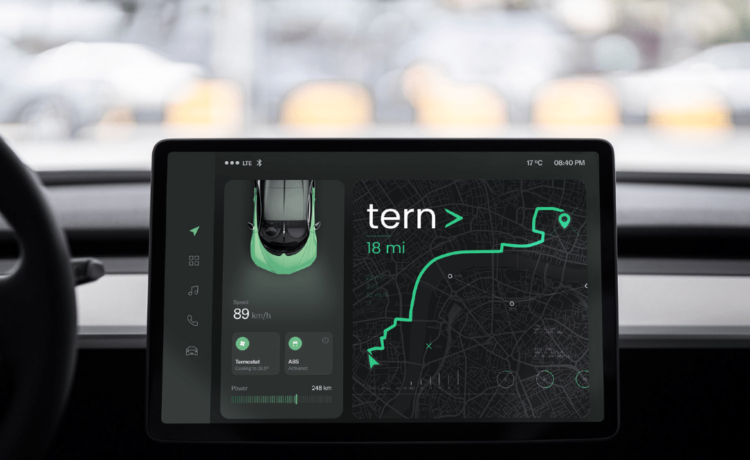
Tern AI came out of stealth in February and just raised a $4.4 million seed round from Scout Ventures, Shadow Capital, Bravo Victor VC and Veteran Fund. The startup has come up with a so-called Independently Derived Positioning System (IDPS) that can recognize the position of a vehicle or person without relying on satellite signal. That means no threat of jamming, construction or dead zones getting in the way of a precise position.
“We can do GPS’s job without having to call to space and say, ‘Where am I?’” said Moore.
The current system works by having GPS receivers in cars or phones pick up signals from satellites orbiting Earth. The signals contain satellite information and the precise time that the signals are sent. The GPS receivers then use the time it took for each signal to travel to calculate the distance to each satellite. By triangulating the distances, the receiver can determine its exact position, which is then displayed on apps like Google Maps or Waze.
This approach (shared by newer constellations like Europe’s Galileo) creates a global and standardized positioning technology, but also one that is susceptible to local disruption. For instance, GPS spoofing has been used to steer commercial vessels into U.S. Navy shipping lanes, and some shipping companies have experienced jammed signals that completely disrupt operations. While it’s not likely your car’s GPS system is going to be targeted by agents of adversary states, there are plenty of military and civilian assets that are at risk and would welcome a more secure solution.
Tern AI’s IDPS is powered by an AI model that ingests vehicle and phone sensor data in real time, as well as third-party map data, to provide a consistent and precise position. This model can be downloaded as a software package to a compatible vehicle’s infotainment system. If the vehicle isn’t compatible, the system can be downloaded to a smartphone. Tern’s model can use phone sensor data to help determine a position, but in some cases, the smartphone will need to pull car sensor data from the vehicle’s on-board diagnostics port.
Moore said the goal is for leading mapping products like Apple Maps, Google Maps or Waze to pull positioning information from Tern’s AI model, rather than from GPS. The startup plans to reach out to those vendors in the future to negotiate integrating directly with them.
Tern AI’s biggest selling point is that it uses AI to parse through sensor data, like speed and motion sensors, that are already available on smartphones and vehicles. Moore noted that Tern doesn’t rely on computer vision and cameras to help it determine positioning.
The use of existing sensors is what prompted Diana Furchtgott-Roth, former deputy assistant secretary for Research and Technology at the DOT, to call Tern AI’s technology a “low-cost answer to a problem that the [DOT] has been working on for decades.”
Other alternatives to GPS satellites like low Earth orbit satellites and terrestrial beacons are, while impressive, very expensive to install and maintain.
“GPS technology has not meaningfully changed in 50 years, and what we’re seeing put forth as solutions to resolve or mitigate risk are just marginal improvements. It’s not true innovation,” said Moore.
He noted that while there have been improvements to GPS, the fundamental nature of the tech hasn’t changed, nor have there been sufficient advancements to protect GPS from becoming a target.
“One of our founding principles was ‘No Signal,’ meaning we are not going to look externally to help us determine where we are. Everything that you have available to you can do that now if you add intelligence to it.”
Tern has primarily validated its technology through internal testing based on the U.S. Department of Transportation’s framework. Moore says Tern’s IDPS can position vehicles within 4 meters of accuracy, which he says is in line with the DOT’s current guidance for emergency services.
The startup is gearing up to begin testing in July with its go-to-market partner, a giant in the logistics, shipping and delivery space that Moore couldn’t name. Tern’s commercial launch is scheduled for September.
The startup is also talking to emergency services and autonomous last-mile delivery companies, industries that “rely on good position information to accomplish their task or complete a job.” In the future, Moore said he also expects the Department of Defense and the DOT to be partners one day.
“When we first met Tern AI, what stood out the most was how differentiated and scalable their approach was to solving a critical problem in national security,” said Stephen DiBartolomeo, principal at Scout Ventures. “When we came to understand the practical commercial applications and the compatibility with road autonomy, their vision for redefining positioning resonated with us.”
Correction: This article was updated to clarify that Tern AI has not yet reached out to mapping companies to integrate its technology.


